The City of Baraboo was in the process of selecting a site and location for a new community fire and EMS station, with the need to meet a couple of important safety and efficiency goals.

The site should be located somewhere both convenient and quick to reach by fire and emergency personnel. It also needed to equally access call locations around the community and ultimately minimize call response time.
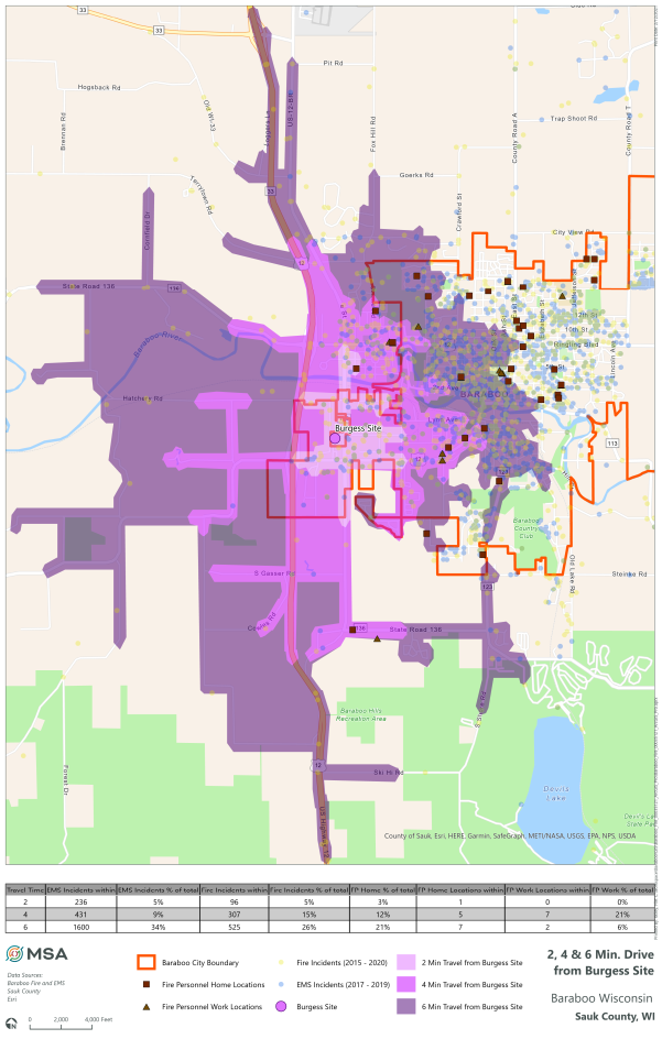
MSA GIS professionals were asked to assist with site selection by means of mapping and geo-locating a variety of proposed station locations as well as the home and work addresses of fire and EMS personnel. The City also provided MSA with a record of the last 2,058 calls for fire services and the last 4,652 EMS calls. All of these locations were then geo-located, and MSA used GIS spatial analysis tools to measure and map drive times for each potential new station site. The resulting maps provided data to illustrate what distance a vehicle could travel in two-, four-, and six-minute increments during typical morning traffic conditions.
Once the drive-time maps were complete, MSA again utilized spatial analysis to determine how many fire and EMS members lived and worked within each of the zones. And, how many fire or emergency calls originated from each of the proposed site and drive-time areas. The numbers allowed MSA to determine a percentage of calls and first responders within each drive time area. The higher the percentage in a given category for a drive time provided direct evidence of the amount of coverage at each potential site.
This data was integral in assisting the City of Baraboo with choosing a site for their new facility that would most effectively and efficiently serve residents of their community in emergency situations. By being proactive in their site selection planning and incorporating GIS-driven solutions, City leaders and fire and EMS staff were able to make an objective and informed decision about which site would truly benefit the community of Baraboo best.


