Civic engagement in the Village of Somerset is on the rise, thanks to a new suite of custom GIS public involvement applications created by MSA.
The development of these “apps” comes after the implementation of an Adopt-a-Road type of application created for the community in 2020 after a request for assistance in finding methods to clean up community roadways, parks, and riverbanks. The ArcGIS-based platform proved so successful that Somerset has been utilizing it during the week of Earth Day ever since — a fun and interactive tradition of civic engagement.
MSA GIS professionals have since been engaged to create other public involvement apps for the community, including a similar Adopt-a-Hydrant App, Parcel Finder App, Resident Issue Reporter App and associated Resident Issue Status App — as well as the continuation of the Volunteer Street Cleanup (Adopt-a-Road) Application.
Adopt-a-Hydrant
The Adopt-a-Hydrant App is a simple and time-saving way to solicit help from residents in clearing space around community fire hydrants after snowfall. Volunteers sign up to clear just 3 feet of space after snow, which greatly reduces the time it takes emergency response teams to access water if/when they need it — resulting in quicker emergency response and a higher chance of saving homes, businesses, and lives.
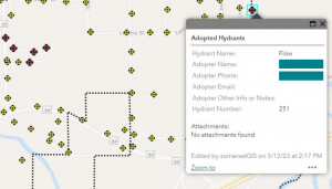
Built upon the foundation of ArcGIS, app viewers can geo-locate on a map all community fire hydrants and see which might be most convenient for them to adopt. Hydrants available for adoption are shown in yellow, and those that have been adopted are shown in red. Individuals or groups interested in adopting a hydrant can easily click on the available location and use Smart Editor to edit fields about the adoption including adopter names and contact information (visible to Village utility leaders only). There is also a place to name one’s adopted hydrant or upload photos taken with this newest adopted “member of the family.”
Parcel Finder
The Parcel Finder App is common in municipalities and provides users with the ability to search within a map for parcel and property lines and boundaries, as well as information about the lot number, owner name, address, tax ID and more. The Parcel Finder App also provides a tool to print groups of labels for public notifications coming from Village staff or fellow residents. The parcel finder uses a live feed of St. Croix County data, so it is always as up to date as it can be regarding resident information.
Resident Issue Reporter & Issue Status
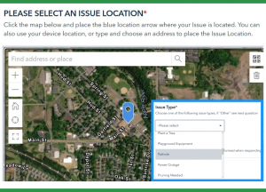
The Resident Issue Reporter App is a handy means to specifically locate and draw attention to a variety of municipal infrastructure or public welfare concerns — with the ability to follow up on Village response and completion with the accompanying Resident Issue Status App.
The first step in the issue reporter app is to engage with an online map of the Village of Somerset and position a blue arrow at the location of the issue or complaint. This can be done by zooming in on a map, utilizing the user’s device GPS location or by entering a specific address. From here, there is a drop-down menu of issue types to choose from, ranging from “Dead Animal” to “Debris on Road,” “Flooding,” “Litter,” Pothole,” Pruning Need,” “Sewer Backup,” “Tree Hazard,” and more. There are fields in which to enter details about the issue, the date of submission to the Village, contact information and photo uploads, if desired.
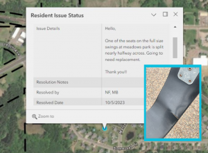
Step two is engaging with the Resident Issue Status App which tracks the above-mentioned issues including type, when it was resolved, how it was resolved, who it was resolved by or if the inquiry was forwarded along to another party for resolution — like the local police department or a third-party utility.
Volunteer Street Cleanup
The Volunteer Street Cleanup App allows the public to adopt a street segment or a local park in the Somerset area and commit to periodic trash clean-up. Participants can view which road segments or parks are available for adoption (shown in red), which are adopted (orange), and mark when clean-up has occurred (green). Volunteers can also share additional information about their adopted roadway such as upcoming planned clean-up dates, the number of volunteers requested, time spent, etc. Whenever a clean-up is complete, that total mileage is added to an overall Clean Streets Summary graphic for the Village to track progress — resulting in great time- and cost-savings for Village maintenance crews.

