In 2023 the City of Middleton reached out to the MSA GIS team to develop a one-stop shop for Pavement Surface Evaluation and Rating (PASER) system analytics and future roadway planning. Utilizing the new Experience Builder environment available in ArcGIS Online, the MSA developed a series of three dashboards that could be accessed from one convenient webpage. Along with the dashboards, the team also assisted in splitting the city’s roadways into sections for more manageable PASER collection.
Streets Overview Dashboard
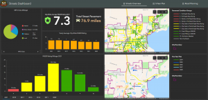
The first dashboard is a Streets Overview. It contains average citywide PASER scores as well as other roadway statistics such as mileage per MPO class (local, collector, minor arterial, arterial, etc.), surface material, roadways groups by pavement condition and road ownership. Most importantly, it shows a graph of mean PASER history which indicates that roadways in the city are, on average, improving. This tool provides city administrators great value and peace of mind in seeing first-hand that the money being put towards community roadway improvements is paying off.

Five-year Plan Dashboard
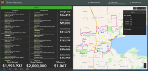
The second dashboard is a Five-year Plan which displays all roads in the queue for maintenance in the next five years and their associated costs. Each year is color-coded and given its own interactive list of road segments, which when clicked into, reveal the parameters of the roadway segment to be upgraded, individual costs per segment, associated comments, and the type of improvement to be made. Previously, this data existed in an Excel spreadsheet. Migrating the data to GIS allows Middleton’s pavement managers to see precisely where these roads lie in the city as well as leverage existing roadway attributes such as width and material to gain greater insight into the roadway, its condition and future maintenance needs.

Roadway Planning Dashboard
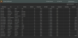
The third dashboard is a Roadway Planning dashboard to display “priority ratings” for each segment of road. These priority ratings are calculated from a custom formula created by the City of Middleton and recalculated nightly using an ArcGIS Notebooks script. The priority rating takes into account several factors about the road, such as PASER score and MPO Class. The city can use the priority ratings to respond to questions from the public about when their street may see repairs, as well as plan and budget for future repairs as identified in the Five-year Plan.

The City of Middleton now has a foundational tool from which to objectively assess community pavement conditions and plan for improvements. It allows leaders to make data-driven decisions about priority projects, optimize community funds and track progress toward reaching its goals in real time.
