Independence Downtown Revitalization Plan
“Celebrate our Spirit,” say the residents of Independence, Iowa (pop. 6,097). Yet, celebrating economic independence and resiliency has been a struggle for this community, located conveniently — and competitively — between three large metropolitan areas: Waterloo to the west by 26 miles, Cedar Rapids to the south by 39 miles, and Dubuque to the east by 68.
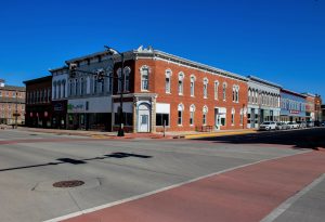
The Independence downtown district was once its economic hub, home to bustling businesses and ornate buildings — many listed on the National Register of Historic Places. While its bones retain much of the historic character, buildings need renovation, commerce is dwindling, and many business owners are nearing retirement with no succession plan — and no online presence, unable to compete in a thriving e-commerce era or with three retail markets within a one-hour drive.
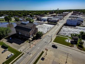
Downtown is also bisected by the Wapsipinicon River and located within a FEMA-designated floodplain. This is detrimental because floodplain locations do not qualify for critical funding dollars such as Community Development Block Grants (CDBG) commonly utilized for renovation, infrastructure upgrades and revitalization projects such as this. The city is also restricted from building new businesses or structures within the floodplain.

Recognizing a list of challenges, Independence leaders sought a new direction for the future of the city’s downtown, with goals of fostering growth, development and resilience. MSA was asked to study and develop an Independence Downtown Plan to serve as a living guide to improve and attract business, spur commercial investment, incentivize long-range economic planning, attract young professionals and revitalize the downtown corridor.
Among many public engagement tools in the process, an ArcGIS crowdsourcing app was also used as an engagement tool. This GIS-driven application was custom configured for Independence and provided citizens with an online map and icons to geographically pinpoint opportunities, areas needing improvement, or community assets related to buildings and roads; ADA and multi-modal improvements; community assets and historical preservation.
While reviewing existing conditions in downtown Independence, MSA utilized Retail MarketPlace, a database identifying supply and demand gaps in retail sales and consumer spending developed by Esri. This helped the team analyze spending trends within 5-, 30-, and 45-minute drive times from Downtown Independence and determine what local demand exists, what unmet demand is going to neighboring retail markets and what amount in overall retail trade is being spent by residents outside the City of Independence — in this case, an estimated $15 million.
All of this data and public feedback informed the development of the Independence Downtown Plan document, with chapters dedicated to Urban Design (aesthetics, streetscaping and accessibility), a Revitalization Plan (flood zone challenges, recreational opportunities and ideas for improvements in four core sectors), and Action and Implementation Plan (goals-setting, action steps, budgetary and zoning impacts, and funding resources).
Since completion and adoption of the plan, multiple campaigns to restore historic buildings have commenced, the City has successfully pursued several Catalyst state grants to revitalize key buildings in the downtown, new owners have joined the downtown marketplace, and the community has a clear set of short-, medium- and long-range goals to continue improving and revitalizing the picturesque heart of their community.
Client
City of Independence
Location
Independence, IA
Services Provided
Contact Project Lead

Shawn O’Shea, AICP, ASEL, sUAS
Client Service Manager, Market Lead - State and Federal
Related Projects
La Porte City Main Street Rehabilitation & Redevelopment
Robust community planning leads to downtown revitalization, boosted recreation and commerce.
MoreCity of Waverly Multi-Community Plan Updates & Collaborative Engagement
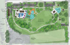
The City of Waverly and MSA planners elected to develop not one, not two, but four unique planning documents simultaneously — under the umbrella of one public engagement process. The four documents include an updated Comprehensive Plan, new Bike and Pedestrian Plan, new Park and Open Space Plan, and new Memorial Park Master Plan. The plans complement and overlap in ways unlikely to materialize in a more traditional single-plan approach and offer great opportunity to gain efficiencies, save on cost, amplify public participation, and introduce a new, more all-inclusive approach to community planning.
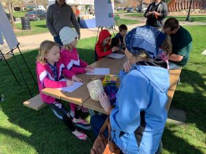
A robust public engagement campaign was a goal from the start. Outreach centered around the Planning Process Engagement Portal website — a user-friendly and easily searchable hub of content that offered full language translation capabilities. Participants could also choose to receive updates or access surveys by email, text, or both. This meant better inclusion for individuals without internet access. The portal facilitated three online surveys and included an interactive ArcGIS crowdsourcing map, a comprehensive planning FAQs guide, links to the City’s five existing plans, a planning process and projects overview, draft concepts for review, and announcements about upcoming open-house meetings, community workshops and pop-up events. MSA also conducted one-on-one interviews with public and private entities potentially impacted, met regularly with a dedicated Steering Committee and created activities geared specifically for kids to share their park visions with paper and crayons — an activity that reminded everyone of the importance of community planning and its impact on future generations.
Tying plans together ensures revisiting them together. Since comprehensive plans tend to be reviewed with more frequency, what perfect time to also review the plans developed in tandem? While many stand-alone plans find themselves collecting dust in the archives, those created in collaborative fashion with others are less likely to get lost in the shuffle. Overlapping plan development and plan review improves plans’ vitality and relevance — allowing them to remain the living, breathing documents they are intended to be.
Bundling planning efforts also allows the City to look at long-range growth, development, and land use opportunities as a cohesive whole. These things inform where new parks and trails are needed to connect residents with business districts, public services, schools, and transportation hubs. And similarly, the popularity and use of parks and trails can inform where new or different development should transpire. One informs the other, and vice versa. The plans speak each other’s language and listen to each other’s needs.
The result is four community plans working together in one coordinated, symbiotic manner to help guide future development. It is an inventive approach to a conventional practice and an excellent means to help create communities of resilience and lasting value. All four Waverly plans were formally adopted by the City Council on February 20, 2023.
The City of Waverly and planning team of MSA, Toole Design and Councilman-Hunsaker were together chosen to receive the 2023 Best Practice Award from the American Planning Association (APA) of Iowa.
More