The Pheasant Branch Creek Corridor Trail is a lush and wooded 1.7-mile excursion through the heart of Middleton, anchored on one end by the Pheasant Branch Conservancy near Lake Mendota. It is a popular destination for bikers, walkers, runners and multi-modal use, meandering through parks and green spaces alongside Pheasant Branch Creek.

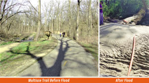
In August of 2018 the City of Middleton and surrounding areas received over 11 inches of rain in just a 12-hour span, exceeding NOAA’s statistics for a 1,000-year event by almost 4 inches. This flooding of the Pheasant Branch Creek corridor caused significant damage to streambanks, pedestrian bridges, trail segments and vegetation. Portions of the creek forged new channels altogether. And the trail? Left largely in ruins.

City leaders knew they needed more than a simple act of restoration; they needed a new foundation for resilience — infrastructure upgrades that would withstand any future stormwater events. MSA was selected in 2020 to provide engineering consulting services for the complex reconstruction project, focusing specifically on restoring the trail and fortifying the six pedestrian bridges alongside.
MSA park and recreation engineers, structural engineers, surveyors, GIS analysts and landscape architects began the work in earnest, acknowledging the desire to revive the creek corridor as quickly as possible while developing design solutions deeply rooted in ‘cost versus risk’ analysis. Resiliency and floodproofing would be top of mind and MSA was determined to provide City leadership with the most accurate historical, statistical and projected data about flood mitigation costs so that they could make the most informed and budget-conscious decisions possible.
Work began with a preliminary investigation and review of existing conditions, soil borings and LiDAR (Light Detection and Ranging) survey results. At each bridge crossing, MSA conducted a hydraulic analysis to determine the baseline flood elevation, overtopping frequency, stream velocity and scour potential. During these evaluations, it was noted that the bridge superstructures had been previously inspected and considered in good condition. However, many of the base pan foundations had been undermined by scour and were predicted to incur even more erosion — to the point of eventual failure if left in their existing configurations.

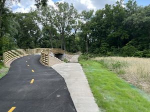
MSA team members felt they could reuse the majority of the existing superstructures, provided additional mitigation measures were put in place to improve hydraulic capacity and minimize damage to the structural foundations during future flood events. The recommendation was to construct new, deep, pile-supported foundations. These would be invulnerable to frost heaving and spring settlement, unlike the existing pan foundations, and would be more cost effective than traditional driven steel pilings. MSA also resolved to raise the structure elevations of each bridge onto higher resilient concrete abutments to provide a greater hydraulic opening and enlarge the spaces around the newly reset bridges to accommodate bypass flood water without adversely impacting the structures.
Next, to address the trail, which had been largely demolished during the course of the flood event. Designs for the new trail were directly informed by the larger creek corridor restoration project, and as such, needed to respond to the primary goal of fortifying Pheasant Branch Creek and the surrounding environment against large stormwater events. MSA would need to balance trail alignment with impacts to the stream, trees and vegetation, prioritize safe and accessible use, and design a trail robust enough to handle both short-term construction loads (such as asphalt paving equipment) and long-term user and emergency/maintenance loads without a degradation of the ride or pavement structure.
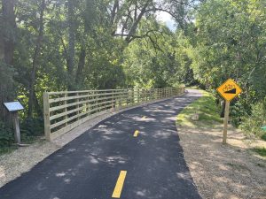
The solution? A 12-foot-wide multi-modal path with occasional side paths to minimize user conflicts — entirely ADA compliant. Trail placement required careful consideration of location and slope in order to reduce blind corners and accommodate both high-speed use — such as by bicyclists or electric scooters — as well as lower-speed use by children, pedestrians, or those using mobility assist devices. The trail’s alignment also needed to minimize side-slope erosion, improve drainage, and help protect the corridor’s natural resources. Now complete, the new asphalt trail will support modern use, in conformance with modern design standards — with an improved vertical and horizontal alignment that upgrades safety to the maximum extent practical.

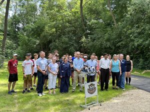
Prior to the 2018 flood, Middleton’s Pheasant Branch Creek Corridor offered visitors the unique experience of enjoying a native riparian environment all within an urban setting. A beloved recreational spot and cross-city connector, this restoration project has been not simply about rebuilding, but revitalizing what was lost — and giving it a more sustainable, resilient future. The project officially re-opened to public use with a community ribbon-cutting ceremony held August 10, 2023.
This project was chosen to receive a 2024 Engineering Excellence State Finalist Award from ACEC Wisconsin.

