Simulations for “what-if” scenarios.
Just as floods can be forecasted, so can a community’s level of preparedness. Comprehensive planning is the key, utilizing the tools and expertise available to proactively assess flood risk and mitigate flood damage. Two of the most thorough means to do this are through stormwater modeling and comprehensive floodplain mapping.
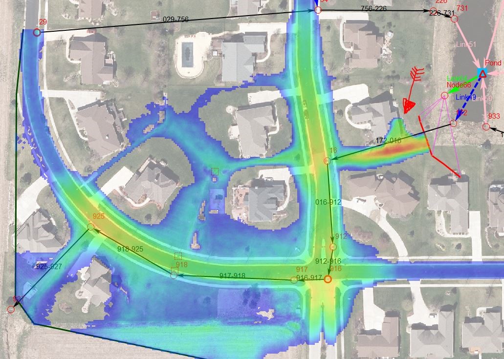
Our water resources professionals employ the computer model XP-SWMM to construct 2D models that help define the scope and magnitude of a community’s flood risks and subsequent solutions. This technology also leverages Light Detection and Ranging (LiDAR) data, generally collected by air with survey aircraft or drones, to map the ground and surface. The entire surface of the flood “study area” is evaluated in the model, and the model’s calculations determine the direction of the flood plan. Not only does this allow for better visualization of how potential flood waters might interact with a community’s drainage system, it does so in a more comprehensive manner with less required field survey.

Model showing “max-depth” of flooding from a potential 100-year event.
Advanced floodplain mapping.
The software can also be used to create more comprehensive floodplain and hazard maps for a municipality, which can be used for floodplain management, hazard identification and flood insurance rating. They define a community’s flood zones, boundaries and the base flood elevation, which together reveal the overall flood risk.
While most communities have FEMA-produced flood maps, these are only helpful to establish a base line. FEMA will only map areas at the request of the state government, and this generally means that only areas with known problems are mapped – therefore, leaving out areas of potential concern. FEMA maps are also often developed over very large areas, and as a result, may lack the level of precision and sophistication that technologies such as 2D modeling can afford. When it comes to flood preparedness, an ounce of prevention is worth a pound of cure, and communities can’t afford to skimp on the details.

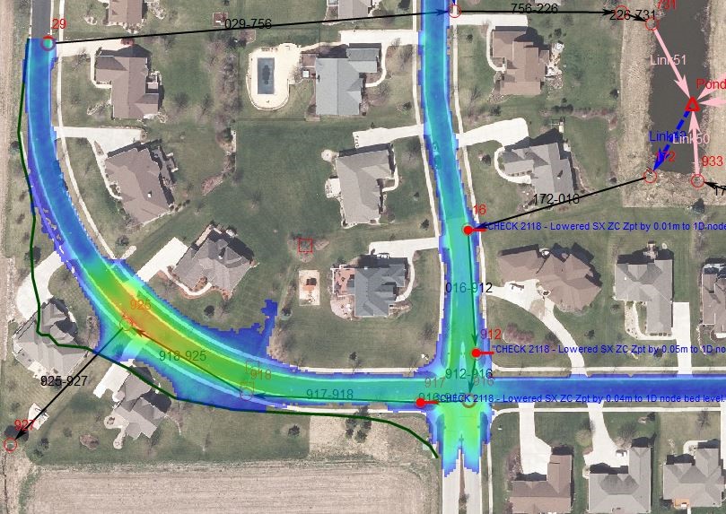
Model revealing an improved scenario after incorporating suggested improvements to a stormwater pond.
The perfect companion to digital modeling for flood mitigation is GIS. Here, we’re able to create realistic renderings of floodplains and boundaries by pairing digital elevation model (DEM) data with GIS-coded, land use-based surface roughness data. The result mimics the actual terrain of the area, revealing topographic changes in relief or surfacing, in addition to providing a powerful tool for floodplain managers.
Floodplain maps need frequent updating because many factors affecting floodplains change over time. A community expands and develops in new areas. Buildings exist in different places. Even scientists’ estimates for rainfall patterns and the runoff response of the land can change. All of this impacts how water accumulates and flows within an area, and all of this impacts what a floodplain map looks like.
Interactive, full-motion visualization.
Once the flood models have been rendered and the maps generated, we can also provide a video representation of how a watershed behaves in a flood, creating a realistic vision of the ‘what if’ scenario. This comes in the form of a full-motion animation, allowing the viewer to witness how potential water might flow through—and impact—a variety of systems, neighborhoods and natural features within a community.
This product is also highly interactive. Within the full-motion model, a user can draw cross-section lines at any location within the map where they might wish to learn more about the hydrograph levels at that particular place. The hydrograph levels reveal information such as the rate of discharge/flow past a specific static point, as generally expressed in cubic feet per second, or cfs. In addition, the user can elect to turn on “velocity vectors,” which illustrate how flow magnitude and direction change over time.
Putting it all together.
The bottom line is that communities need to be prepared, and what is top-of-mind is the safety and security of the residents who call your community home. We recognize it can be daunting to consider the many facets of flood preparation and asset management. We’re here to help. Start a conversation with our water resources team today to learn how we can help protect the people and places you hold dear.
